|
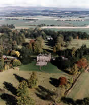 Touch Estate comprises some 3750 acres of
parkland, forestry, farmland and hill. Historically the Estate
has been agriculturally orientated, centered around six farms;
of these, five lie on carse ground reclaimed by draining
during the 18th Century and the other a hill farm on the Touch
Hills. Touch Estate comprises some 3750 acres of
parkland, forestry, farmland and hill. Historically the Estate
has been agriculturally orientated, centered around six farms;
of these, five lie on carse ground reclaimed by draining
during the 18th Century and the other a hill farm on the Touch
Hills.
Much of the fabric and landscape of the estate remains
the same as it was in the 18th century. Many of the buildings
and nearly all of the hedge lines, field boundaries, woodland
and parkland, illustrated in estate maps of 1797 and 1810
remain unchanged.
Recently however, as all sectors of agriculture have
declined, the Estate has had to move and change with the
times. Over the past two years, many of the houses and
cottages have been renovated to a high standard and are now
available to let. The conversion of the 'A' listed Stable
Block from a semi dilapidated condition to modern offices has
been a commercial success as well as a significant historic
and architectural achievement. Touch House has been a
rewarding venue for corporate seminars, training sessions,
weddings and many charity events.
We hope that this reorientation will allow us to look
after the estate to a high standard and continue with a
programme of inward investment to preserve and maintain its
historic fabric; most notably, Touch House.
While Touch House remains a much loved family home, the
house and Gardens do open to the public for a variety of
events through the year. Dates and events change annually, but
we are nearly always open for doors open day, usually
scheduled for the first week in
September.
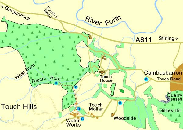
Directions to the Touch
Estate:
Leave Stirling via the Allan
Park. Take the Kings Park Road, a tree lined avenue which runs
alongside the park. Eventually you will come to a roundabout.
Turn right and go all the way along Park Place. The road turns
to the left into Birkhill Road, which will take you over the
M9 motorway and into Cambusbarron.
At the T-Junction on Main
Street, make your way out of the village on the Touch Road.
Travel about 1/3mile (750km) and take the first turning on the
left (A). You will see a ruined house to your left and
Cambusbarron Quarry on the skyline. Further on you will see a
burn running alongside the road.
At the point where the road
divides (B). Do not take the signposted Private Road
to Brooklands and Woodside. Keep to the right and follow
the road up the hill. Drive carefully as there are cattle
grids and sheep wandering on the road. Eventually, you see
some cottages on your left and waterworks in front of you
(C).
Walk down, alongside the
waterworks, past the old wooden scout hut. As you round the
corner into a small, enclosed field (D), there are old
railway sleepers over a patch which can be boggy. Look over
the dry stone dyke to get a great view of Stirling Castle and
the Carse.
Go through the gate and you
will see a track winding around to the left of the farmhouse.
Follow the track and remember to close any gates behind you.
The track starts to wind it's way down the hill but keep
heading straight towards the trees ahead of you. Climb over or
go under the fence (E), then make your way into the
trees.
You will see and hear Touch Burn in the gully and should be
able to find a path. Sections of the path are fine but it
tends to disappear in places. The path gets covered in fallen
leaves and can be slippery. This part of the walk can be
dangerous so be careful and keep a close watch on children.
You will see some smaller
waterfalls and on the lower stretch of the burn you can get
down to the water. Keep walking upstream and don't be tempted
to climb down. Be very careful as the burn flows deep through
the gorge and the path runs very close to the edge.
The path is hard to follow in places but keep going until you
come to a row of trees rooted on an old dry stone dyke. Up on
the left you will see a line of trees and a wire fence running
along by the dyke. Proceed to the right, along the line of the
dyke and then carefully make your way down to the burn (F).
Care should be taken while
descending as the bank is steep and covered in loose material.
If the burn isn't flowing too fast, you can make your way
across the stepping stones to explore Gilmour's Linn, a
peaceful place to spend some time. This scenic waterfall has a
deep cave running behind it and Bonnie Prince Charlie is
reputed to have hidden here when fleeing after the Battle of
Culloden.
From here, follow the route back to where you started from. If
you are pushed for time and prefer a shorter walk to Gilmour's
Linn, you can drive up the hill, and park on the stretch of
road just before the waterworks.
[1]
[2] 3 | 

